Rover Project
The Rover 1 Project is poised to produce a range of downstream critical and precious minerals, including gold doré, 99% copper, 99% cobalt, and high-grade 96.5% magnetite. The Pre-Feasibility Study (PFS), completed on 5 December 2022, models an efficient underground mining operation with a modern 500,000 tonnes per annum (tpa) processing plant, specifically designed to produce high-value gold, copper, cobalt, and magnetite products.
Location
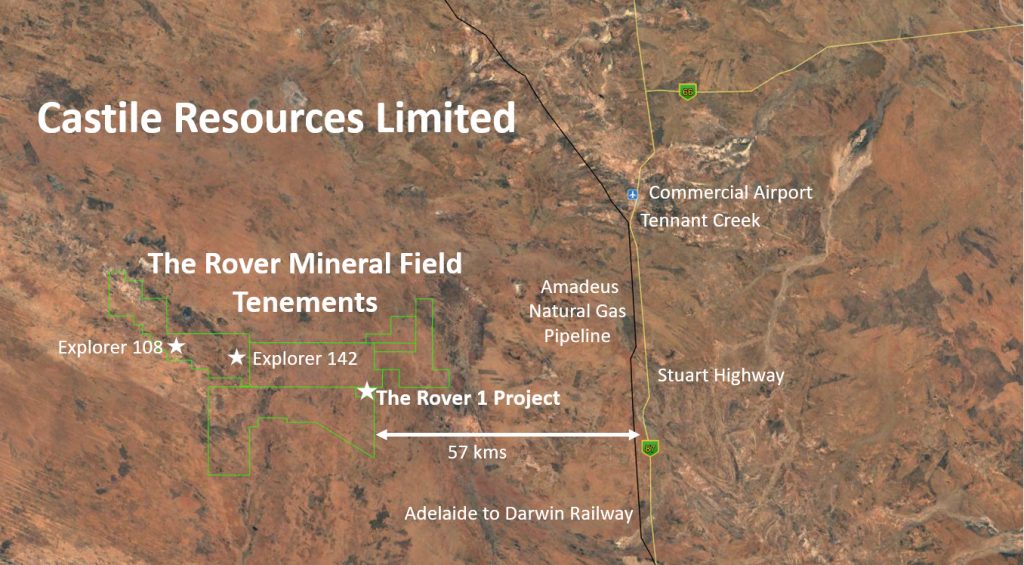
The 100% owned Rover Project is located 80 km southwest of the township of Tennant Creek in the Northern Territory. The total tenement area is approximately 1,054 km² covering a significant proportion of the Rover Mineral Field
Proximity to Infrastructure – Commercial Airport, Railway, Major Highway and Natural Gas Pipeline
Opportunity
The main mineralisation style within the Project is Iron Oxide Copper Gold (IOCG). This deposit type is known to host large scale economic copper and gold mineralisation such as the world class Olympic Dam in South Australia and Candelaria in Chile.
The Rover Mineral Field is interpreted to be a southern repeat or extension of the Tennant Creek Mineral Field. Tennant Creek IOCG’s have historically produced approximately 157t of gold, 345,000t of copper, 14,000t of bismuth, 220t of selenium and 56t of silver from 130 mines, with the majority of production derived from 12 deposits.
Currently, there are three advanced deposits with mineral resources in the Rover Mineral Field;
-
Rover 1
Rover 1 is an IOCG deposit type with strong similarities to Warrego in the Tennant Creek field. A current JORC 2012 Mineral Resource has been estimated of 6.9 Mt at 1.74 g/t Au, 2.07 g/t Ag, 1.2% Cu, 0.14% Bi, 0.06% Co for 386koz gold, 459koz silver, 83kt copper, 9.4kt bismuth and 4.1kt cobalt inclusive of indicated and inferred classified material. The Mineral Resource is reported at a 2.5 g/t AuEq (gold equivalent) block cut-off. View Rover 1
-
Explorer 108
Explorer 108 is a lead-zinc deposit with geological attributes comparable to the Mt Isa deposit with a JORC 2012 Mineral Resource of 11.9Mt at 11.1g/t Ag, 2.0% Pb, 3.2% Zn for 4.25Moz silver, 237kt lead, 385kt zinc, above a lower cut-off grade of 2.5% combined Pb-Zn. The Mineral resource is reported inclusive of indicated and inferred classified material. View Explorer 108
-
Explorer 142
Explorer 142 is a IOCG deposit type, similar to other Tennant Creek Style Cu-Au deposits. The deposit is estimated to contain an Inferred Mineral Resource of 170kt at 0.21 g/t Au and 5.2% Cu for 1.2koz gold and 9.2kt copper. This figure was reported above a lower cut-off of 2.5% Cu. View Explorer 142
Exploration
The whole Project area is covered by recent sediments which overly extensive flat-lying Cambrian sedimentary units of the Wiso Basin. This basin sequence unconformably overlies the Proterozoic basement hosting mineralisation. The Project area remains under explored outside of the above resources, with numerous targets yet to be fully investigated.
Given the depth of overlying cover over the entire Rover Project area, there is little to be gained by employing conventional grass-roots exploration methods. Instead, initial exploration involved acquisition of high resolution geophysical data. Aerial magnetic and surface gravity surveys were employed to identify subsurface massive ironstone bodies. Historically, these generally coincident anomalies were modelled, ranked and tested by diamond drilling.
More recently, advances in other geophysical techniques have meant that metal potential can be determined and modelled over a number of targets at moderate cost prior to committing to expensive deep drilling programs.
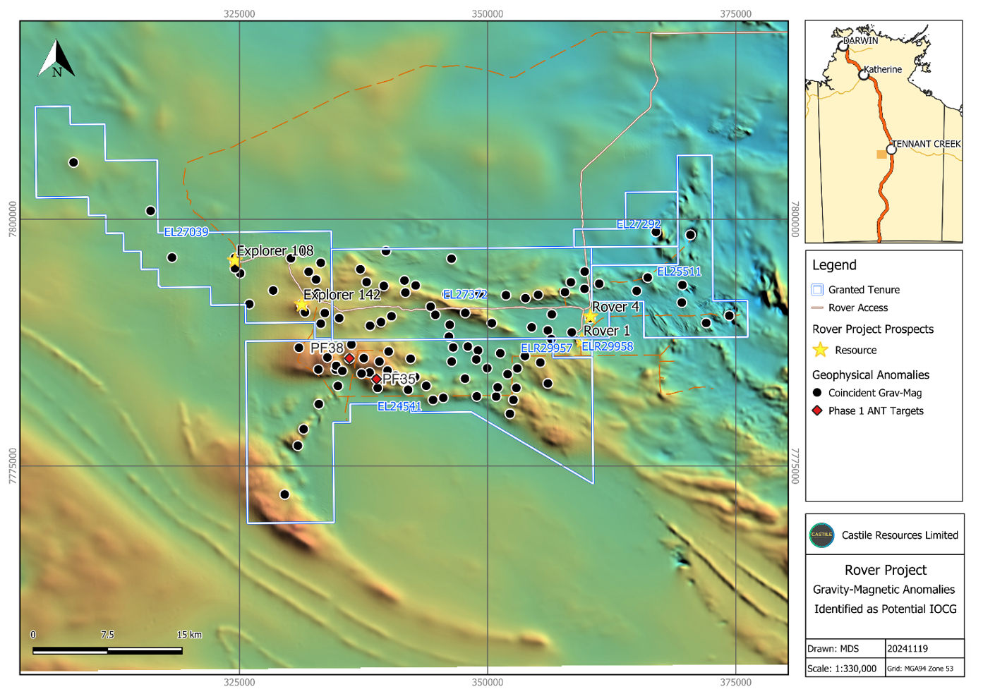
Castile is committed to the continued evaluation of more than 40 untested geophysical targets. This includes reprocessing historic geophysical surveys with current processing algorithms, additional geophysical surveys in the form of Induced Polarisation (IP) and Transient Electromagnetics (TEM) and generating inversions to effectively target drilling.
In addition to green field exploration, the Rover 1, Explorer 108 and Explorer 142 deposits all possess open extensional mineralisation and conceptual target zones to be tested.
Exploration – Ambient Noise Tomograpahy
Castile successfully completed a proof-of-concept passive seismic survey over Rover 1 using the latest Ambient Noise Tomography (ANT) modelling algorithms. The test was conducted over the Jupiter Ironstone which hosts part of the Rover 1 deposit, and proved successful in showing that the ANT survey can accurately discriminate ironstone bodies at depth.
Mainstream geophysics techniques such as gravity and magnetics are used to recognise Iron Oxide Copper Gold (IOCG) formations due to their magnetic and gravity signatures but due to the ‘infinite depth’ problem in forward modelling, they can be unreliable in determining the exact depth and dimension of the signal source (ironstone). As a result, previous exploration drilling relying on conventional magnetic and gravity modelling techniques have failed to intersect the anomaly source, despite some targets having strong signals. This may have been due to assumptions limiting existing modelling techniques at the time, being unable to determine the depth of the target accurately which also effects the lateral extents of the modelled source.
The value to Castile of this technology is not just in confirming the presence of a source of a strong magnetic-gravity response, but ensuring that we will know the depth and location of the ironstone orebody with a high probability to intersect the target. We won’t just be hitting targets; we will be avoiding drilling holes that previously may have missed their target altogether. In addition, the ANT technology will allow Castile to revisit highly ranked anomalies which were unsuccessfully drill tested by previous operators.
Castile has over 100 untested and a further 16 high ranking, unsuccessfully tested, co-incident magnetic-gravity anomalies wholly within the Rover Project tenure with Pathfinder 35 and 38 being the top ranked untested targets. Castile initiated the first true exploration ANT survey at Pathfinder 35 in the quarter. This will be followed by a survey at the nearby Pathfinder 38 anomaly. These are both strong coincident magnetic-gravity anomalies and considered highly prospective for IOCG mineralisation like Castile’s flagship mineral deposit, Rover 1. Due to the remarkable success of the proof-of-concept survey, Castile will now apply the technology to our high priority exploration targets. If the targets provide the conducive results expected, they will both be drilled in the April 2025 drilling program.
Regional Geology and Mineralisation
The Rover Project area is covered entirely by recent sediments which blanket extensive flat-lying Cambrian siltstone, dolomitic siltstone and sandstone units of the Wiso Basin. This basinal sedimentary sequence unconformably overlies Proterozoic basement, with a thickening trend from less than 70 m in the east to in excess of 200 m in the west. Outcrops of the Woodenjerrie Beds, the Junalki Formation (both age correlatives of the Warramunga Formation), the Ooradidgee Group, and the Hatches Creek Group, with minor granite and porphyry, have been mapped about 20 km east of the project area.
While Warramunga Formation rocks do not outcrop in the area, Castile geologists have correlated meta-sedimentary lithologies observed in drill core at the Rover 1 and Explorer 142 prospects to characteristic Warramunga Formation sequences that host the numerous IOCG deposits in the Tennant Creek Mineral Field. In addition, the magnetic signature of the area is similar to the response seen from the Warramunga Formation around Tennant Creek. Detailed aeromagnetic data strongly suggests that the Warramunga Formation sedimentary sequence extends under the Wiso Basin over an area in excess of 1000 km², and most likely represents a fold or thrust belt repeat of the Tennant Creek Mineral Field.
The metallogenic model that applies to IOCG deposits of the Tennant Creek mineral field also applies to the Rover Mineral Field. The presence of abundant ironstone and extensive alteration in conjunction with high order structures and associated Cu-Au mineralisation provides indirect evidence that the host rocks of the Rover Field mineral deposits correlate with the Warramunga Formation.
A key driver of IOCG formation globally is broadly coeval major thermal events – generally this manifests as widespread granitoid intrusion. In the case of Tennant Creek this is the Tennant Creek Super Suite associated with the Barramundi Orogeny. Within the Rover Mineral Field, aerial magnetics have identified several intrusive bodies under cover in proximity to favourable stratigraphy. Importantly for the Project, a large 40 x 20km intrusive body is interpreted on the southern tenement boundary